
Vehicle Detection from Overhead Satellite Images in Saudi Arabia with YOLOv12
Abstract
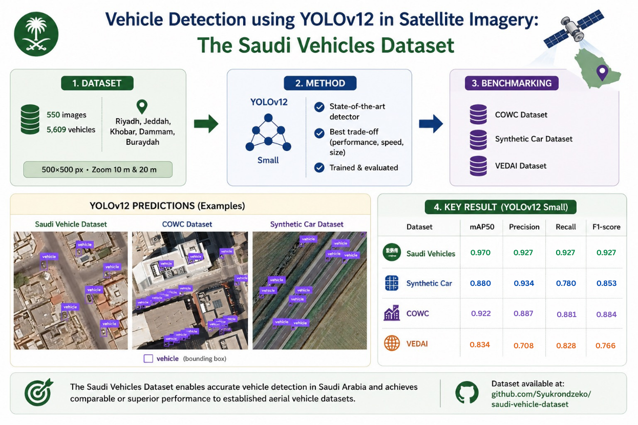
One of the primary challenges in urban areas of the Kingdom of Saudi Arabia is managing traffic flow and implementing effective urban planning strategies in densely populated cities. Utilizing satellite imagery for vehicle counting presents an effective solution to enhance urban planning and economic monitoring. Based on a review of the literature, the lack of vehicle counting datasets using satellite imagery is a significant gap. To address this, we introduce the Saudi Vehicles Dataset, which comprises 410 images, each 500x500 pixels, with 5,609 manually annotated vehicles. To ensure the dataset's quality and generalization, we benchmark it against two other satellite datasets: Car Synthetic and COWC. Benchmarking was performed using the latest version of the YOLO object detection algorithm, YOLOv12. The results indicate that our dataset yields comparable performance metrics to the other datasets. Specifically, when YOLOv12 was trained on the Saudi Vehicles Dataset, it achieved the high scores for mAP50, recall, precision, and F1-score, with values of 0.977, 0.939, 0.945, and 0.942, respectively. While the best performance was observed on the synthetic dataset, achieving a perfect precision score of 1, the Saudi Vehicles Dataset showed superior performance in terms of recall, precision, and F1-score. The dataset is publicly available for use and can be accessed via this link: https://github.com/Syukrondzeko/saudi-vehicle-datasetHow to Cite
Muhamad Syukron, Radical Rakhman Wahid (2026). Vehicle Detection from Overhead Satellite Images in Saudi Arabia with YOLOv12. Journal of Engineering and Technological Sciences, Vol. 58 No. 6 (2026): Vol. 58 No. 6(2026): December (In Progress), 885-893. https://doi.org/10.5614/j.eng.technol.sci.2026.58.6.9
Metrics
References
Benjdira, B., Khursheed, T., Koubaa, A., Ammar, A. & Ouni, K. (2019). Car Detection using Unmanned Aerial Vehicles: Comparison between Faster R-CNN and YOLOv3, 2019 1st International Conference on Unmanned Vehicle Systems-Oman (UVS), 1–6. https://doi.org/10.1109/UVS.2019.8658300
Dupont, M. (2024). Comparing YOLOv10 with Other Object Detection Models. https://www.labelvisor.com/comparing-yolov10-with-other-object-detection-models/. Accessed 2 June 2026.
Guven, C., Karaduman, O. & Avci, E. (2021). A Review on Urban Intelligent Traffic Management Problems: Sensors and Methods, 2021 2nd International Informatics and Software Engineering Conference (IISEC), 1–6. https://doi.org/10.1109/IISEC54230.2021.9672412
Hill, C. (2021). Automatic Detection of Vehicles in Satellite Images for Economic Monitoring [University of South Florida]. https://digitalcommons.usf.edu/etd/8792/. Accessed 2 June 2026.
Khanam, R., & Hussain, M. (2024). YOLOv11: An Overview of the Key Architectural Enhancements. arXiv preprint arXiv:2410.17725. https://arxiv.org/abs/2410.17725.
Kwon, Y. (2023). YOLO-Label. https://github.com/developer0hye/Yolo_Label. Accessed 2 June 2026.
Lin, T.-Y., Goyal, P., Girshick, R., He, K., & Dollár, P. (2018). Focal Loss for Dense Object Detection. https://arxiv.org/abs/1708.02002
Lin, T.-Y., Maire, M., Belongie, S., Bourdev, L., Girshick, R., Hays, J., Perona, P., Ramanan, D., Zitnick, C. L., & Dollár, P. (2015). Microsoft COCO: Common Objects in Context.
Maptionnaire. (2023). GIS in Urban Planning: Application, Tools & Examples. https://www.maptionnaire.com/blog/gis-in-urban-planning-benefits-application-examples
Minetto, R., Segundo, M. P., Rotich, G. & Sarkar, S. (2021). Measuring Human and Economic Activity from Satellite Imagery to Support City-Scale Decision-Making During COVID-19 Pandemic, IEEE Transactions on Big Data, 7(1), 56–68. https://doi.org/10.1109/TBDATA.2020.3032839
Ministry of Municipal and Rural Affairs. (2019). Saudi Cities Report 2018 – Executive Summary. https://saudiarabia.un.org/sites/default/files/2020-01/SSCR2018-ENG_0.pdf
Mundhenk, T. N., Konjevod, G., Sakla, W. A., & Boakye, K. (2016). A large contextual dataset for classification, detection and counting of cars with deep learning. In B. Leibe, J. Matas, N. Sebe, & M. Welling (Eds.), Computer Vision – ECCV 2016 (Lecture Notes in Computer Science, Vol. 9907). Springer, Cham. https://doi.org/10.1007/978-3-319-46487-9_48
Orić, M., Galić, V., & Novoselnik, F. (2024). Synthetic car dataset for vehicle detection: Integrating aerial and satellite imagery. Data in Brief, 53, 110105. https://doi.org/10.1016/j.dib.2024.110105
Razakarivony, S. & Jurie, F. (2016). Vehicle detection in aerial imagery : A small target detection benchmark. Journal of Visual Communication and Image Representation, 34, 187–203. https://doi.org/10.1016/j.jvcir.2015.11.002
Redmon, J., Divvala, S., Girshick, R., & Farhadi, A. (2016). You only look once: Unified, real-time object detection. In 2016 IEEE Conference on Computer Vision and Pattern Recognition (CVPR) (pp. 779–788). IEEE. https://doi.org/10.1109/CVPR.2016.91
Redmon, J., & Farhadi, A. (2018). YOLOv3: An incremental improvement. arXiv preprint arXiv:1804.02767. https://arxiv.org/abs/1804.02767. Accessed 16 September 2026.
Stuparu, D.-G., Ciobanu, R.-I. & Dobre, C. (2020). Vehicle Detection in Overhead Satellite Images Using a One-Stage Object Detection Model. Sensors, 20(22), 6485. https://doi.org/10.3390/s20226485
Tian, Y., Ye, Q., & Doermann, D. (2025). YOLOv12: Attention-centric real-time object detectors. In Advances in Neural Information Processing Systems 38 (NeurIPS 2025), 87151–87175. https://doi.org/10.52202/085713-2627
License
Copyright (c) 2026 by Authors

This work is licensed under a Creative Commons Attribution 4.0 International License.
Downloads
Date Log
- Submitted
- April 15, 2025
- Accepted
- September 8, 2026
- Published
- October 12, 2026
Keywords
- deep learning
- satellite image
- saudi arabia
- urban planning
- vehicle detection
- yolov12


