Comparative Analysis of Photogrammetry Tools for Monitoring Trench and Pipeline Progress Towards Sustainable Construction
Downloads
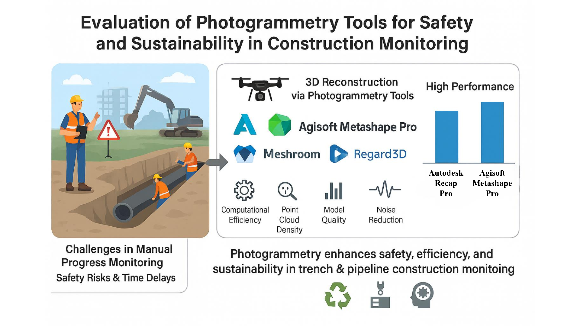
The construction of trenches and pipelines is essential to the infrastructure sector, but because of safety and technical concerns, progress monitoring is difficult. This study assesses how well photogrammetry, a cost-effective and adaptable Industry 4.0 technology, can improve safety and sustainability in construction monitoring. The graphical user interface, computational efficiency, point cloud density, model quality, percent completion, and noise in the produced 3D models were the criteria used to evaluate the six photogrammetry tools: Autodesk Recap Pro, Agisoft Metashape Pro, COLMAP, VisualSFM, Meshroom, and Regard 3D. Performance under specified conditions was examined using a trench and pipeline dataset. The results show that Agisoft Metashape Pro and Autodesk Recap Pro performed exceptionally well, offering thorough and precise 3D reconstructions with excellent models and low noise. This research promotes the use of photogrammetry by emphasizing its advantages over conventional methods in terms of affordability and sustainability. It highlights photogrammetry's contribution to resilient and sustainable practices and provides industry experts with advice on how to choose appropriate methods for tracking building progress. The results help stakeholders feel more confident about implementing photogrammetric technologies that are suited to various building settings.
Al Khalil, O. (2020). Structure from motion (SfM) photogrammetry as alternative to laser scanning for 3D modelling of historical monuments. Open Science Journal, 5(2), https://doi.org/10.23954/osj.v5i2.2327 .
Alhamadah, A., Mamun, M., Harms, H., Redondo, M., Lin, Y.-Z., Pacheco, J., Salehi, S., & Satam, P. (2024). Photogrammetry for digital twinning industry 4.0 (i4) systems. 2024 IEEE/ACS 21st International Conference on Computer Systems and Applications (AICCSA),
Alidoost, F., & Arefi, H. (2017). Comparison of UAS-based photogrammetry software for 3D point cloud generation: a survey over a historical site. ISPRS Annals of the Photogrammetry, Remote Sensing and Spatial Information Sciences, 4, 55–61.
Alizadehsalehi, S., & Yitmen, I. (2016). The Impact of Field Data Capturing Technologies on Automated Construction Project Progress Monitoring. Procedia Engineering, 161, 97–103. https://doi.org/https://doi.org/10.1016/j.proeng.2016.08.504
Anwar, N., Izhar, M. A., & Najam, F. A. (2018). Construction monitoring and reporting using drones and unmanned aerial vehicles (UAVs). The Tenth International Conference on Construction in the 21st Century (CITC-10),
Balado, J., Garozzo, R., Winiwarter, L., & Tilon, S. (2025). A systematic literature review of low-cost 3D mapping solutions. Information Fusion, 114, 102656.
Becker, R., Galayda, L., & MacLaughlin, M. (2018). Digital photogrammetry software comparison for rock mass characterization. ARMA US Rock Mechanics/Geomechanics Symposium,
Benton, D. J., Warren, S. N., Sunderman, C. B., & Richardson, J. R. (2018). A novel application of photogrammetry to ground convergence monitoring in underground excavations. Novel Optical Systems Design and Optimization XXI,
Bilal, M., Oyedele, L. O., Qadir, J., Munir, K., Ajayi, S. O., Akinade, O. O., Owolabi, H. A., Alaka, H. A., & Pasha, M. (2016). Big Data in the construction industry: A review of present status, opportunities, and future trends. Advanced engineering informatics, 30(3), 500–521.
Bosché, F., Ahmed, M., Turkan, Y., Haas, C. T., & Haas, R. (2015). The value of integrating Scan-to-BIM and Scan-vs-BIM techniques for construction monitoring using laser scanning and BIM: The case of cylindrical MEP components. Automation in Construction, 49, 201–213.
Burns, J., & Delparte, D. (2017). Comparison of commercial structure-from-motion photogrammety software used for underwater three-dimensional modeling of coral reef environments. The International Archives of the Photogrammetry, Remote Sensing and Spatial Information Sciences, 42, 127–131.
Casella, E., Drechsel, J., Winter, C., Benninghoff, M., & Rovere, A. (2020). Accuracy of sand beach topography surveying by drones and photogrammetry. Geo-Marine Letters, 40, 255–268.
Catalucci, S., Marsili, R., Moretti, M., & Rossi, G. (2018). Comparison between point cloud processing techniques. Measurement, 127, 221–226. https://doi.org/https://doi.org/10.1016/j.measurement.2018.05.111
Colomina, I., & Molina, P. (2014). Unmanned aerial systems for photogrammetry and remote sensing: A review. ISPRS Journal of photogrammetry and remote sensing, 92, 79–97.
Delgado-Vera, C., Aguirre-Munizaga, M., Jiménez-Icaza, M., Manobanda-Herrera, N., & Rodríguez-Méndez, A. (2017). A photogrammetry software as a tool for precision agriculture: a case study. International Conference on Technologies and Innovation,
Elhalawani, M. A., Zeidan, Z. M., & Beshr, A. A. (2021). Implementation of close range photogrammetry using modern non-metric digital cameras for architectural documentation. Geodesy and Cartography, 47(1), 45–53.
Fu, K., Peng, J., He, Q., & Zhang, H. (2021). Single image 3D object reconstruction based on deep learning: A review. Multimedia Tools and Applications, 80(1), 463–498.
Gagliolo, S., Ausonio, E., Federici, B., Ferrando, I., Passoni, D., & Sguerso, D. (2018). 3D cultural heritage documentation: A comparison between different photogrammetric software and their products. The International Archives of the Photogrammetry, Remote Sensing and Spatial Information Sciences, 42, 347–354.
Girardeau-Montaut, D. (2016). CloudCompare. France: EDF R&D Telecom ParisTech, 11(5).
Grussenmeyer, P., & Al Khalil, O. (2008). A comparison of photogrammetry software packages for the documentation of buildings.
Huang, R., Xu, Y., Hoegner, L., & Stilla, U. (2022). Semantics-aided 3D change detection on construction sites using UAV-based photogrammetric point clouds. Automation in Construction, 134, 104057.
Janiszewski, M., Prittinen, M., Uotinen, L., Torkan, M., & Rinne, M. (2023). Rapid photogrammetric method for rock mass characterization in underground excavations. ISRM Nordic Rock Mechanics Symposium-NRMS,
Jarahizadeh, S., & Salehi, B. (2024). A comparative analysis of UAV photogrammetric software performance for forest 3D modeling: A case study using AgiSoft photoscan, PIX4DMapper, and DJI Terra. Sensors, 24(1), 286.
Javadnejad, F., Slocum, R. K., Gillins, D. T., Olsen, M. J., & Parrish, C. E. (2021). Dense point cloud quality factor as proxy for accuracy assessment of image-based 3D reconstruction. Journal of Surveying Engineering, 147(1), 04020021.
Jones, C. A., & Church, E. (2020). Photogrammetry is for everyone: Structure-from-motion software user experiences in archaeology. Journal of Archaeological Science: Reports, 30, 102261.
Kim, C., Son, H., & Kim, C. (2011). The effective acquisition and processing of 3D photogrammetric data from digital photogrammetry for construction progress measurement. In Computing in civil engineering (2011) (pp. 178–185).
Kingsland, K. (2019). A comparative analysis of two commercial digital photogrammetry software for cultural heritage applications. New Trends in Image Analysis and Processing–ICIAP 2019: ICIAP International Workshops, BioFor, PatReCH, e-BADLE, DeepRetail, and Industrial Session, Trento, Italy, September 9–10, 2019, Revised Selected Papers 20,
Kingsland, K. (2020). Comparative analysis of digital photogrammetry software for cultural heritage. Digital Applications in Archaeology and Cultural Heritage, 18, e00157.
Knodell, A. R., Wilkinson, T. C., Leppard, T. P., & Orengo, H. A. (2023). Survey archaeology in the Mediterranean world: Regional traditions and contributions to long-term history. Journal of Archaeological Research, 31(2), 263–329.
Kopsida, M., Brilakis, I., & Vela, P. A. (2015). A review of automated construction progress monitoring and inspection methods. Proc. of the 32nd CIB W78 Conference 2015,
Ma, P., Mondal, T. G., Shi, Z., Afsharmovahed, M. H., Romans, K., Li, L., Zhuo, Y., & Chen, G. (2024). Early detection of pipeline natural gas leakage from hyperspectral imaging by vegetation indicators and deep neural networks. Environmental Science & Technology, 58(27), 12018–12027.
Mahami, H., Nasirzadeh, F., Hosseininaveh Ahmadabadian, A., & Nahavandi, S. (2019). Automated progress controlling and monitoring using daily site images and building information modelling. Buildings, 9(3), 70.
Moselhi, O., Bardareh, H., & Zhu, Z. (2020). Automated data acquisition in construction with remote sensing technologies. Applied Sciences, 10(8), 2846.
Musarat, M. A., Alaloul, W. S., Khan, A. M., Ayub, S., & Jousseaume, N. (2024). A survey-based approach of framework development for improving the application of internet of things in the construction industry of Malaysia. Results in Engineering, 21, 101823.
Noordermeer, L., Gobakken, T., Næsset, E., & Bollandsås, O. M. (2021). Economic utility of 3D remote sensing data for estimation of site index in Nordic commercial forest inventories: a comparison of airborne laser scanning, digital aerial photogrammetry and conventional practices. Scandinavian Journal of Forest Research, 36(1), 55–67.
Omar, T., & Nehdi, M. L. (2018). Automated data collection for progress tracking purposes: a review of related techniques. Facing the Challenges in Structural Engineering: Proceedings of the 1st GeoMEast International Congress and Exhibition, Egypt 2017 on Sustainable Civil Infrastructures 1,
Pal, A., Lin, J. J., Hsieh, S.-H., & Golparvar-Fard, M. (2023). Automated vision-based construction progress monitoring in built environment through digital twin. Developments in the Built Environment, 100247.
Palestini, C., Basso, A., & Perticarini, M. (2022). Machine learning as an alternative to 3D photomodeling employed in architectural survey and automatic design modelling. International Archives of the Photogrammetry, Remote Sensing and Spatial Information Sciences, 48(2/W1-2022), 191–197.
Paneru, S., & Jeelani, I. (2021). Computer vision applications in construction: Current state, opportunities & challenges. Automation in Construction, 132, 103940.
Pazhoohesh, M., & Zhang, C. (2015). Automated construction progress monitoring using thermal images and wireless sensor networks. GEN, 101(01).
Pučko, Z., Šuman, N., & Rebolj, D. (2018). Automated continuous construction progress monitoring using multiple workplace real time 3D scans. Advanced engineering informatics, 38, 27–40.
Qureshi, A. H., Alaloul, W. S., Hussain, S. J., Murtiyoso, A., Saad, S., Alzubi, K. M., Ammad, S., & Baarimah, A. O. (2022). Evaluation of photogrammetry tools following progress detection of rebar towards sustainable construction processes. Sustainability, 15(1), 21.
Qureshi, A. H., Alaloul, W. S., Murtiyoso, A., Saad, S., & Manzoor, B. (2022). Comparison of photogrammetry tools considering rebar progress recognition. International Archives of the Photogrammetry, Remote Sensing and Spatial Information Sciences, 43, 141–146.
Radman, K., Jelodar, M. B., Lovreglio, R., Ghazizadeh, E., & Wilkinson, S. (2022). Digital technologies and data-driven delay management process for construction projects. Frontiers in Built Environment, 8, 1029586.
Rahaman, H., & Champion, E. (2019). To 3D or not 3D: choosing a photogrammetry workflow for cultural heritage groups. Heritage, 2(3), 1835–1851.
Rao, A. S., Radanovic, M., Liu, Y., Hu, S., Fang, Y., Khoshelham, K., Palaniswami, M., & Ngo, T. (2022). Real-time monitoring of construction sites: Sensors, methods, and applications. Automation in Construction, 136, 104099.
Rebolj, D., Pučko, Z., Babič, N. Č., Bizjak, M., & Mongus, D. (2017). Point cloud quality requirements for Scan-vs-BIM based automated construction progress monitoring. Automation in Construction, 84, 323–334.
Róg, M., & Rzonca, A. (2021). The impact of photo overlap, the number of control points and the method of camera calibration on the accuracy of 3D model reconstruction. Geomatics and Environmental Engineering, 15(2), 67–87.
Ruzgiene, B. (2007). Comparison between digital photogrammetric systems. Geodezija ir kartografija, 33(3), 75–79.
Saif, W., & Alshibani, A. (2022). Smartphone-based photogrammetry assessment in comparison with a compact camera for construction management applications. Applied Sciences, 12(3), 1053.
Selvaggi, I., Dellapasqua, M., Franci, F., Spangher, A., Visintini, D., & Bitelli, G. (2018). 3D comparison towards a comprehensive analysis of a building in cultural heritage. International Archives of the Photogrammetry, Remote Sensing and Spatial Information Sciences, 42, 1061–1066.
Shao, Z., Yang, N., Xiao, X., Zhang, L., & Peng, Z. (2016). A multi-view dense point cloud generation algorithm based on low-altitude remote sensing images. Remote Sensing, 8(5), 381.
Su, Z. (2021). Advanced 2D and 3D Computer Vision for a Smarter City-From Image to Point Cloud. Hong Kong University of Science and Technology (Hong Kong).
Turkan, Y. (2012). Automated construction progress tracking using 3D sensing technologies.
Vinodkumar, P. K., Karabulut, D., Avots, E., Ozcinar, C., & Anbarjafari, G. (2024). Deep learning for 3d reconstruction, augmentation, and registration: A review paper. Entropy, 26(3), 235.
Vlachos, M., Berger, L., Mathelier, R., Agrafiotis, P., & Skarlatos, D. (2019). Software comparison for underwater archaeological photogrammetric applications. The International Archives of the Photogrammetry, Remote Sensing and Spatial Information Sciences, 42, 1195–1201.
Wright, A. E., Conlin, D. L., & Shope, S. M. (2020). Assessing the accuracy of underwater photogrammetry for archaeology: A comparison of structure from motion photogrammetry and real time kinematic survey at the east key construction wreck. Journal of Marine Science and Engineering, 8(11), 849.
Xu, Y., Ye, Z., Huang, R., Hoegner, L., & Stilla, U. (2020). Robust segmentation and localization of structural planes from photogrammetric point clouds in construction sites. Automation in Construction, 117, 103206.
Yalcinkaya, M., & Singh, V. (2015). Patterns and trends in building information modeling (BIM) research: A latent semantic analysis. Automation in Construction, 59, 68–80.
Copyright (c) 2026 Muhammad Hassaan Farooq Khan, Wesam Salah Alaloul, Muhammad Ali Musarat, Abdul Mateen Khan, Socheatra Soeung

This work is licensed under a Creative Commons Attribution 4.0 International License.